Archive Record
Images
Metadata
Title |
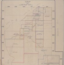
Map of School Districts in Jefferson County In 1912 |
Object Name |
Map |
Caption |
1912 map of the 28 school districts in Jefferson County. |
Creator |
Morris, Melissa |
People |
Reilly, John |
Scope & Content |
This is an 8.5" x 11" photocopy of the original map stored at the Jefferson County Clerk & Recorders Office; map was "approved March 6, 1912, John Reilly, Chairman Board County Commissioners" is written in the upper left hand corner; the map indicates the following school district numbers and names: #1-Clancy #2-Jefferson #3-Wicks #4-Whitehall #5-Basin #6-Bernice #7-Boulder #8-Corbin #9-Gregory #10-Webber #11-Cold Springs #12-Elkhorn #13-Mitchell #14-Elk Park #15-Pleasant Valley #16-Jefferson Island #17-Willow Creek #18-Finn #19-Lump #20-Cardwell (name is handwritten) #21-Woodville #22-Travis #23-Comet #24-Cavern #25-Amazon (handwritten) #26-Gurcka (handwritten) #27-Montana City (handwritten) #28-Shoddy Springs (handwritten) |
Date |
1912 |
Collection |
School |
Search Terms |
Amazon Basin Bernice Boulder Cardwell Cavern Clancy Cold Springs Comet Corbin Elk Park Elkhorn Finn Gregory Gurcka Jefferson City Jefferson County School Districts Jefferson Island Lump City Mitchell Montana City Pleasant Valley Shoddy Springs Travis Webber Whitehall Wickes Wicks Willow Creek Woodville |
Catalog Number |
2022.2.1 |
Subjects |
1912 Maps School districts |